By Jeff Kapembwa
Yesterday, we carried a story on the forecast rainfall in Zambia for this weekend titled: “Zambia Braces for heavy rainfall weekend-Experts”:
According to NGA AgroClimate Tech, a regional weather analysis agency:
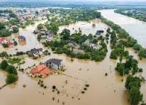
• It may rain heavily in Zambia this weekend with all-weather easterlies-East, North, South and West expected to converge on the Southern African state this weekend.
• the country will sit right at the meeting point of four different air masses, the westerlies, easterlies, northeasterlies, and southeasterlies.
• This atmospheric convergence is expected to spark widespread heavy rainfall and thunderstorms across much of the country.
• This rainfall surge, according to the report, is being powered by a strong subtropical high-pressure system (1027hPa) positioned to the south, and the converging winds.
Below is the MET’s position:
The Zambia Meteorological Department’s Director Edson Nkonde, while acknowledging fall of the rains, argues that the predictions are somewhat exaggerated, with “some sentiments being quoted out of context, falling short of Social Media Buzz, than from expert perspective”.
This post is a classic example of social media weather-watching, mixing some correct general concepts with significant exaggeration and meteorological inaccuracies.
Here is a review and correction of the information presented.
1. The Core Claim: “Widespread Heavy Rainfall”
This appears to be a significant exaggeration.
While the rainy season is indeed beginning, forecasts for the coming days (Nov 5-9) over central Zambia (like Lusaka) primarily show light to moderate rain and scattered or isolated thunderstorms.
Precipitation descriptions from various public forecasts include “a couple of showers,” “a stray evening thunderstorm,” and “passing showers.”
While some sources note the possibility of “heavy rain locally” (which is com…
This post is a classic example of social media weather-watching, mixing some correct general concepts with significant exaggeration and meteorological inaccuracies.
Here is a review and correction of the information presented.
1. The Core Claim: “Widespread Heavy Rainfall”
This appears to be a significant exaggeration.
While the rainy season is indeed beginning, forecasts for the coming days (Nov 5-9) over central Zambia (like Lusaka) primarily show light to moderate rain and scattered or isolated thunderstorms.
Precipitation descriptions from various public forecasts include “a couple of showers,” “a stray evening thunderstorm,” and “passing showers.”
While some sources note the possibility of “heavy rain locally” (which is common with any thunderstorm), this is very different from the “widespread heavy rainfall” claimed in the post, which implies a major, large-scale flooding event.
Corrected Information: The seasonal rains are starting, bringing a chance of scattered showers and thunderstorms, which is normal for early November.
2. The Meteorological Cause: “Four Air Masses”
This is a meteorological dramatization and is incorrect.
The primary driver for Zambia’s rainy season is the seasonal southward migration of the Inter-Tropical Convergence Zone (ITCZ).
This zone is not a meeting of four air masses. It is the convergence of two:
The moist, warm Congo Air Mass (or northwesterly flow).
The cooler, drier South-Easterly Trade Winds.
The post’s mention of “northeasterlies” is also a factor, as monsoonal winds from that direction do feed into the ITCZ, but “four distinct air masses” meeting at one point is not the correct technical description.
Corrected Information: The rainfall is being sparked by the Inter-Tropical Convergence Zone (ITCZ), the well-established seasonal feature that marks the start of Zambia’s rainy season.
3. The Other Factors: High Pressure & Regional Impact
Subtropical High (1027hPa): This part is plausible.
A strong high-pressure system to the south (like the St. Helena High) is a key feature that helps steer the southeasterly trade winds northwards into the ITCZ. The specific pressure (1027hPa) is just a snapshot, but the concept is sound.
Regional Impact: This is correct. The ITCZ is a massive, regional system. Its activation naturally affects Zimbabwe, Malawi, northern Botswana, and Mozambique. This is a shared regional weather pattern.
4. The Conclusion: “Setting in, and in above normal rate”
This is a misuse of terminology.
A weather event (like a week of rain) cannot happen at an “above normal rate.” This term applies to climate—for example, “monthly rainfall accumulation was 150% above normal.”
The post is confusing a weather forecast with a seasonal climate outlook. While some seasonal forecasts (like the WMO’s) point to a developing La Niña, which can lead to above-average rainfall for the season as a whole, it is incorrect to apply that to the first week of rain.
Corrected Information: The seasonal rains are beginning, as expected. It is far too early to make any claims about whether this season’s rainfall will be “above normal.”